
So I'm almost spit out. I'm happy being on my own and have a more defined sense of who I am. Granted, I have no sense of direction (what IS that), but I feel confident that when forks start to come up in the road, I'll make the right choices (knock on wood). I like this stage of life, it's exciting. I've started to confirm what I've learned about myself these past four years – who I am, what I want, where I'd like to go. I have a clearer idea now, and it's begun this awesome route of trying things that I think I'll like and seeing how those experiences play out. This most recent adventure was one of those experiences.
Three weeks ago, I came back to Boston after a one-month stay in Iceland. Our class followed Iceland's Ring Road backwards, camping at different sites for two to six nights at a time. We saw a lot of the country – ancient glaciers, still steaming lava, puffins, and a lot of rain. Along with daily geologic field work, we also had a midterm, final exam, and final project to complete once we returned.
My professor left the project up to us – our instructions were to demonstrate what we've learned. As I've floated along these last couple weeks, I've toyed with different ways to encapsulate my experience in Iceland. I knew that I wanted to use photos as a way to tell the story, but as usual, I also wanted to explain myself, so I knew I wanted to write. That stumped me, until I remembered that I already had a neglected blog. Duh.
So, this will be a long post. Its aim is to share some of what I've learned and observations I made along the way. For those of you who are looking for a lighter read, you can stop here and look at the photos I took while I was there – they're all captioned, so you'll hopefully learn something.
THE PHOTOS
(for fullscreen, select the blue boxes in the upper right corner)
SOME MORE INFORMATION
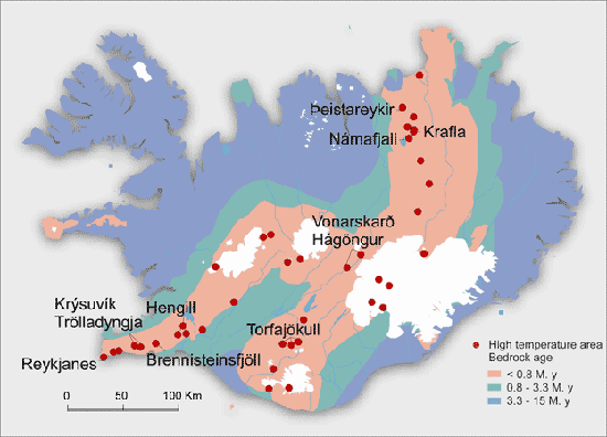 Iceland is more than geologically interesting, it's a geological JACKPOT (things I never thought I'd say). The country sits atop a hotspot* on the boundary of the North American and Eurasian tectonic plates. The land is constantly spreading outward from that area because the plates are moving away from each other. As they move, volcanic eruptions add mass to the land and the country grows. The picture to the right illustrates this – the orange areas are the geologically youngest and have the most active volcanoes, while the blue/purple areas are the oldest.
*The hotspot is also called the "Headless Cat" because 3D images of it look like a cat missing its head.
Many of the famous locations in Iceland owe their creation to a geologic force. Iceland is cool because of how its combination of volcanic and glacial activity shapes its appearance. It was fascinating to see how powerful the earth is and how unstoppable its processes are. Over time, retreating and advancing glaciers have carved out mountains, valleys, lakes, rivers, and plains that are now crucial parts of Iceland's culture – like Þingvellir.
Þingvellir, known as Thingvellir to English speakers, is the site of Iceland's Parliament. As the population of Iceland grew, the ruling chieftains decided that they needed to establish a general assembly. They chose Thingvellir because it was one of the most accessible locations in the country – it took the furthest chieftain only 17 days to reach it. That's a pretty quick travel time, considering that most other journeys were elongated due to casual things like glaciers and piles of jagged lava getting in the way of the horses Icelanders rode to get everywhere.
Thingvellir is geologically significant as well because it sits atop both the North American and Eurasian plates. As the picture to the left shows, the two plates' movement created a rift valley full of fissures and faults. Many of the streams and lakes visible in the photo are rifts that have filled with water. The large crack in the picture is one of the best visualizations of continental drift that we can see today – it's so cool that you can actually see the evidence of how the two plates are moving away from each other!
The most interesting thing to me about Thingvellir is that Icelanders conducted their politics there from 930 to 1798. That's 868 years of negotiations, and 868 years of Icelandic people traveling across ridiculous terrain, like this and this, to participate in their politics. I doubt that people now-a-days have that kind of grit (I'M NOT APATHETIC I'M JUST DISENCHANTED).
SOME FINAL THOUGHTS
I learned more than I thought possible on this trip, and I also know that I've only brushed the surface of the information that Iceland has to teach. I'd love to return, but in the meantime I can busy myself with watching Game of Thrones reruns and pointing out all the geological features in the Iceland scene's backgrounds.

(for fullscreen, select the blue boxes in the upper right corner)
...
SOME MORE INFORMATION
THE BASICS
 Iceland is more than geologically interesting, it's a geological JACKPOT (things I never thought I'd say). The country sits atop a hotspot* on the boundary of the North American and Eurasian tectonic plates. The land is constantly spreading outward from that area because the plates are moving away from each other. As they move, volcanic eruptions add mass to the land and the country grows. The picture to the right illustrates this – the orange areas are the geologically youngest and have the most active volcanoes, while the blue/purple areas are the oldest.
*The hotspot is also called the "Headless Cat" because 3D images of it look like a cat missing its head.
Many of the famous locations in Iceland owe their creation to a geologic force. Iceland is cool because of how its combination of volcanic and glacial activity shapes its appearance. It was fascinating to see how powerful the earth is and how unstoppable its processes are. Over time, retreating and advancing glaciers have carved out mountains, valleys, lakes, rivers, and plains that are now crucial parts of Iceland's culture – like Þingvellir.
 |
| via |
Thingvellir is geologically significant as well because it sits atop both the North American and Eurasian plates. As the picture to the left shows, the two plates' movement created a rift valley full of fissures and faults. Many of the streams and lakes visible in the photo are rifts that have filled with water. The large crack in the picture is one of the best visualizations of continental drift that we can see today – it's so cool that you can actually see the evidence of how the two plates are moving away from each other!
The most interesting thing to me about Thingvellir is that Icelanders conducted their politics there from 930 to 1798. That's 868 years of negotiations, and 868 years of Icelandic people traveling across ridiculous terrain, like this and this, to participate in their politics. I doubt that people now-a-days have that kind of grit (I'M NOT APATHETIC I'M JUST DISENCHANTED).
NOTABLE EXPERIENCES AND THINGS I THINK WERE INTERESTING
- There is an outrageous amount of public pools
- And they're all geothermally heated. Every single one. Which is really cool, at least for our group since we were studying those processes. It was a direct example of people benefitting from natural energy. Because geothermal heat is not in short supply in Iceland, there are pools in almost every single town. That was nice for us, as we would all flock to them from the campsites to swim and shower. It was also amazing to swim outdoors in 40 degree weather, knowing the only reason the water is warm is because the land underneath it is literally boiling.
- The pools also offered the opportunity to be severely culture shocked, as it was mandatory to take thorough showers completely NUDE before swimming. It can be nerve wracking to try and find where and what you're supposed to be doing when you're holding all your clothes in your arms instead of wearing them on your body, but we got accustomed to it faster than I thought we would, though not without some emBAR(E)-ASSing mishaps. Here is a helpful guide I found for swimming in Icelandic pools. Read it or suffer the naked consequences.
- Turf houses are way bigger inside than you'd think they'd be
- Before the trip, we were assigned to read three books on Icelandic history, one of which was Independent People. It's story centers around the life of a sheep farmer named Bjartur of Summerhouses and basically how much of a stubborn asshole he is (the book is a classic though, read if you please). For most of the story, he lives in a turf house he builds himself. Since there are little to no trees in Iceland, natives built themselves houses in the ground out of turf. Based on my impression from Independent people and pictures like this, I thought that these were little one room structures. However, after visiting the turf house at Glaumbær, that assumption was corrected. Turf houses were so effective that Icelanders used turf to build with into the mid-1900's.
- Arctic terns are scary and aggressive
- This photo explains my feelings.
- 1,000 year old ice tastes the same as 5 minute old ice
- While in Vatnajökull National Park, we went on a boat tour the Jőkulsarlón glacier lagoon. As glaciers recede and melt, lagoons form at their base and are filled with meltwater and huge chunks of ice that calve (break) off of the glacier. Our boat guide pulled a piece of ice out of the water and explained its age and then used an ice pick to break it apart for us to eat. Which we, weirdly, did.
- Lava can still be hot 31 years after its erupted
- When we visited the Leirhnjúkur Lava Fields, I was amazed that the land all around us was still steaming, even though the eruption had happened in 1984. Though most of the lava on the surface had cooled, there were still multiple vents pumping steam and sulphur out of the earth all around the area. The rocks were warm and damp to touch. If you moved one away from its resting point, steam would come out of the place it had been. Radical.
SOME FINAL THOUGHTS


